Maps
Europe
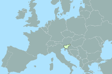
Borders
Austria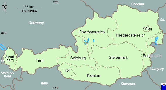
Croatia
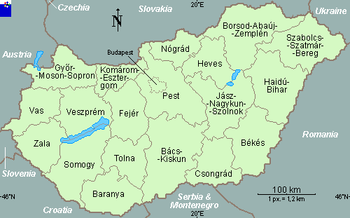
Hungary
Italy
Slovenia
Interactive Map - Select region or country for a more detailed map.

The regions of Slovenia
The most recent regional division of Slovenia created twelve regions: Primorska, Notranjska, Goriska, Gorenjska, Central Slovenia, Dolenjska, Zasavje, Posavje, Savinjsko, Koroska, Podravje, and Pomurje.
Primorska includes the Slovene coast and its hilly hinterland. The warm Adriatic Sea enables a lively tourist industry, saltworks, and commercial fishing. The Port of Koper is the center of the region and Slovenia's maritime gateway to the world. Due to its Mediterranean climate and fertile soil, the hilly hinterland is important for producing Mediterranean crops such as vegetables, wine, and olives.
Notranjska is a predominantly hilly region, covered with karst phenomena and extensive forests. Farmers are mainly occupied with stock breeding, and the forests have encouraged the development of wood processing industries. The karst region boasts outstanding tourist attractions: the intermittent Cerknica Lake, karst caves (Postojna, Kriz, and Skocjan), and rich cave fauna such as the "human fish" (Proteus anguinus). Postojna, the center of the region, is the home of the most frequently visited karst cave in Europe and the Karst Research Institute of the Slovene Academy of Sciences and Arts.
Goriska includes the watershed of the Soca River and the Vipava Valley. The Soca (Isonzo) is known worldwide for the bitter battles of World War I that are vividly documented in the award-winning museum in Kobarid. The Soca has a reputation as Slovenia's most beautiful river, and the warm influence of the Mediterranean reaches far up its valley. The city of Nova Gorica was built after the postwar border with Italy was established in 1947 and has since grown into the true economic and social center of the region. Owing to its casino and entertainment center, the city is often referred to as the "Slovene Las Vegas."
Gorenjska is a highly developed alpine region with outstanding natural beauties. Mount Triglav, the highest peak in the Julian Alps, is one of Slovenia's national symbols, and the mountains of Gorenjska are the most visited in Slovenia. The warm alpine lakes of Bled and Bohinj are very attractive, and the winter resort center of Kranjska Gora is inviting in every season. Planica hosts world championship competition in ski jumping and ski flying. Kranj, the natural center of Gorenjska, is an important industrial town.
Central Slovenia includes the central part of the Ljubljana Basin and the surrounding hills. Major European transportation routes intersect here near the Sava River and routes from the Pannonian Plain to the Adriatic pass through the Ljubljana Gate. Ljubljana, the capital of Slovenia, is home to its parliament and governmental institutions, a university, and the Slovene Academy of Sciences and Arts. In recent decades, Ljubljana has also become Slovenia's largest business center.
Dolenjska extends south from Ljubljana to the Kolpa River that marks the border with Croatia. This hilly karst region of numerous small settlements opened to the world after the construction of the Ljubljana-Zagreb highway in 1958. The regional center Novo mesto is today a notable industrial center (automobiles, pharmaceuticals). Beyond the Gorjanci mountain range spreads the sunny region of Bela Krajina with its numerous natural attractions and interesting folklore (music, dances, customs).
Zasavje along the central Sava River is often referred to as the "Black District". For the last two hundred years, coal has been intensively exploited in this region, spurred especially by the railroad built in the second half of the 19th century. Although coal mining has been rapidly abandoned in recent times and the landscape has been considerably transformed, the old mining towns still give it a special stamp (Hrastnik, Trbovlje, Zagorje).
Posavje covers the region along the lower stream of the Sava River to the Croatian border. Because of its favourable climate and fertile soil, the Krsko Basin and the surrounding hilly slopes are intensively cultivated; large orchards and vineyards are a typical sight. The Krakovski gozd oak forest on the flood plain is a special attraction. Following the first hydroelectric plant built on this section of the Sava River at Vrhovo, the full exploitation of the river is being planned. The town of Krsko is known for Slovenia's only nuclear power plant. Taking advantage of thermal springs near the Sotla River are Atomske Toplice and Rogaska Slatina, Slovenia's largest natural health resorts.
Savinjsko embraces the watershed of the more than one-hundred-kilometer length of the torrential Savinja River that runs from the high Kamnik-Savinja Alps and the Karavanke Mountains to the flat Savinja Valley. The mountain world is distinguished by the glacier-carved valleys (Logarska dolina, Matkov kot, Robanov kot) that form a major tourist attraction, while the Savinja Valley is famous for its hop plantations of the "Savinja golding" variety. In the Zalek Valley, the largest lignite coal mine in Slovenia fostered industrialization and the development of the planned town of Velenje. The center of the region is Celje, once the Roman town Celeia, the seat of a principality in the 15th century, and today the third largest city in Slovenia.
Koroska was once part of the oldest state of the Slovene people and was part of Austrian Carinthia until the end of World War I. It extends across the mountainous world along the Drava, Mezica, and Mislinja rivers. life here has become focused in valleys open to traffic where industry has developed, while isolated farms dominate in the forested mountain areas. Along with the ironworking center of Ravne, Slovenj Gradec has developed as a regional center that UNESCO has proclaimed as a herald of peace due to its special cultural events.
Podravje occupies the fertile Drava and Ptuj flood plains, the hilly regions of Slovenske gorice to the north, Dravinja gorice and Haloze to the south, and the forested Pohorje mountain range to the west. The Drava river, one of the strongest rivers in Slovenia, is dammed at many locations for hydroelectric plants (Fala, Mariborski otok, Zlatolicje, Formin), creating large recreation lakes (Maribor Lake, Ptuj Lake, Ormoz Lake). Exceptional locations in the hills, a mild climate, and favourable soil conditions have enabled the production of top quality white wines that are matured in large wine cellars in Maribor, Ptuj, and Ormoz. On the lower slopes of the Pohorje mountain range above the regional center and university city of Maribor , Slovenia's second largest city, there is winter stadium for women's World Cup slalom competitions and recreational skiing. Ptuj, the Roman Poetovio, is a living museum and the oldest city in Slovenia.
Pomurje (Prekmurje Region) covers Slovenia's largest plain along the Mura River between Austria, Hungary, and Croatia. To the north the plain is bordered by the hills of Goričko, and to the south by the hills of Slovenske gorice. The region is called Slovenia's breadbasket.
In the hills, the production of top quality white wines flourishes and a sparkling wine has been produced in Gornja Radgona for almost 150 years using a natural process brought from France. The outstanding mineral water Radenska-Three Hearts has been bottled in Radenci since 1869 and can now be found on every continent. At numerous locations beside thermal mineral wells, natural health resorts have developed (Radenci, Moravske Toplice, Terme Lendava, Banovci). The regional center of Murska Sobota is the only Slovene town situated entirely on a plane.
Facts and Figures
- 20,273 km2 is the surface area of the Republic of Slovenia
- 1,382 km of borders
- 46.6 km coastline
- 1,964,000 population
- Population density 97.5 per km2
- Nationalities: Slovenes 87.8%, Croats 2.8%, Serbs 2.4%, Muslims 1.4%, Hungarians 0.4%, Italians 0.4%, others 5%
- urban populations 50.1%